- Contact Us
- +91-98111-55335
- [email protected]

Scheme For Promotion Of MSMEs In Defence
June 20, 2020
Electronic Authentication Of Organic Foods
June 26, 2020SOFTWARE & APPS: Software for strategic applications
Software For strategic applications
 AnyLogic
Visit: https://www.anylogic.com
Full version: Paid; free trial
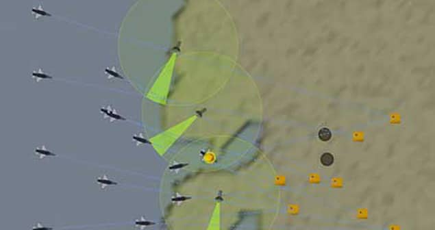
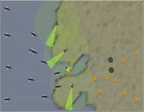
Anylogic software for defence modelling and simulation provides a flexible virtual environment for faster analysis, testing, forecasting, and optimisation of complex processes, systems, and operations necessary to make the right decisions while mitigating risks involved. Modelling of systems required for military planning and management is done prior to their use in different applications, and their role and interoperability is tested. For disaster response scenarios, this is possible by considering environmental variables, human behaviour, and technology systems while creating testing responses.
 EWare
EWare
Visit: https://systematic.com/ ?lang=en
Full version: Paid
EWare by Systematic is a standard-based, off-the-shelf software built for easy deployment in military organisations to help them make accurate tactical decisions to prevent loss of life and property while avoiding ambiguities. This powerful electronic warfare tool allows users to process data reliably before passing it to frontline units that include both day-to-day management and updating of mission-critical data. With improved threat identification, the team can minimise risk of such incidents. It can be customised to the geography of any planned mission.
IFS Maintenix
Visit: https://www.ifs.com/corp
Full version: Paid
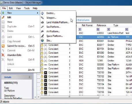
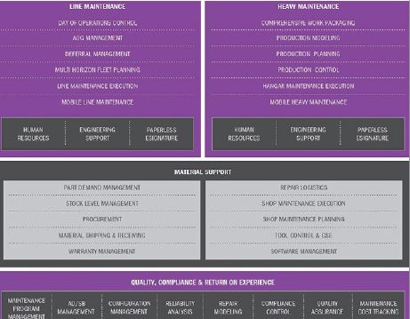
IFS Maintenix is an easily scalable, end-to-end aviation maintenance management software that allows organisations to maximise the revenue potential of assets through standard and predictable maintenance. Users are provided with reliable and timely information, which improves their productivity and efficiency. The software has a component-based architecture featuring controlled workflow and point-of-maintenance access to real-time information, which enables working with any maintenance and engineering (M&E) system. Other features include automated planning, paperless execution, and compliance.
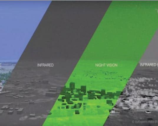 GeorbIS
Visit: https://www.vizexperts.com
Full version: Paid
GeorbIS is a 3D GIS (Geospatial intelligence) platform for visualisation, analysis, and development of data. The software helps to enhance the planning process of defence and paramilitary forces through several ways, such as the area of interest visualisation, real-time sensor data integration, terrain analysis, among others. Besides following global symbology standards like the MIL 2525D, it is OGC certified and also compatible with MIL symbology used by the Indian military along with support for the Indian Military Grid Reference System (IMGRS). It also helps in making intelligent decisions when it comes to forest management, oceanography, and disaster management.
![]() Voyager CommandTRACKER
Voyager CommandTRACKER
Visit: http://www.salientcrgt.com
Full version: Paid
Voyager CommandTRACKER is an incident and asset management system that provides real-time awareness about the location of mobile users and assets, be it in vehicles or on foot via tracking of GPS-enabled portable and mobile radio units. ‘Always On’ geo-fencing alerts and notifications get triggered as assets enter or leave defined areas. Integration of third-party GPS devices to other existing applications or systems enables easy sharing of data amongst command staff, communications specialists, and emergency operations managers for management across multiple locations. (Image Credit: www.salientcrgt.com/newsroom/media-library)
Mobile apps For Strategic Applications
UgCS for DJI
Updated: June 2020
OS: Android and iOS
Download: Full version (free)
 UgCS for DJI allows users to establish a connection between DJI drones (like Phantom 4, Inspire 2, Spark) with GPR mounted on them and UgCS desktop (version 3.5 or higher) ground station for uploading and carrying out a previously planned mission, or to fly the drone in ‘Click&Go’ mode. This enables ground-penetrating radar (GPR) surveys in harsh/hazardous environments without compromising the security of team members. It can also be used as a standalone application for manually flying drones. Other features include Live HD camera view, home position reset, flight simulation, support for metric and imperial units, and so on.
Mgrs & Utm Map
Updated: April 2020
OS: Android and iOS
Download: Full version (free)
 Mgrs & Utm Map was developed to mainly help military personnel with GPS and coordinate systems. The app uses satellite navigation systems such as GPS, GALILEO, and GLONASS (GNSS) supported by smartphones and their sensors to show the most accurate position of the user. There are several location (coordinate) format options, including MGRS, UTM, or Latitude/Longitude. The centre of the map also follows user location while on the move, which enables measurements of distance, altitude, area, and the like. It can even assist users with outdoor activities and sports.
 100% Army Fit
Updated: November 2019
OS: Android and iOS
Download: Full version (free)
100% Army Fit app by the British Army is a training and fitness tool built for prospective recruits who are preparing for an assessment, or even those who wish to achieve the fitness level of military personnel. It allows users to track their goals, which include training curated by fitness coaches for losing weight, increasing muscular strength, improving distance running performance, and the like. Training plans can be customised based on the user’s requirements. The app also offers nutrition advice to ensure that exercises deliver expected results.
Military News
Updated: March 2020
OS: Android
Download: Full version (free)
 Military news app provides the latest news in the field of military/defence taking place around the world by analysing numerous news stories and breaking news from reliable news publishers. Updates on military programmes and such technologies as for military gear and equipment that are happening globally are also provided regularly. This includes notifications for breaking new stories and videos for a better understanding of different situations. Other features include a bookmarking system for future reference, news sharing options, and much more. The latest version comes with a username update option and other improvements for optimisation.
Military Flashlight
Updated: February 2020
OS: Android
Download: Full version (free)
 Military flashlight app allows users to simply swipe for a strobe light and has different strobe light blinking frequencies, including Morse code SOS signal as well as a standard compass dial. Only smartphone camera access is needed for rear flash operation. It caters to all military lovers, veterans, soldier families, and personnel. Users can also personalise the torch with different colours (depicting Army, Navy, Marine Corps, Air Force, and Coast Guard). The ad-free version of this app is paid.